

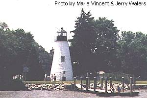
 Concord Point Light is a 36-foot tower that was built in 1827. It is the second oldest tower lighthouse on the Chesapeake Bay and the oldest continuous lighthouse in Maryland. The tower is built at the point where the Susquehanna River meets the tidal flow of the Chesapeake Bay and navigation is very hazardous around this area.
John Donohoo was the designated builder and also built the keeper's dwelling (also known as the O'Neill House) situated across the street. The lighthouse is constructed of Port Deposit granite. The walls are 31" thick at the base and narrow to 18" at the parapet.
The lantern was originally lit with 9 whale oil lamps with 16-inch tin reflectors. In 1854 a sixth-order Fresnel lens was installed. This was later upgraded to a fifth-order Fresnel lens. The lighthouse was automated in 1920.
The ONeill family has served as keepers at Concord Point from 1827 to the mid-1900s. The first ONeill, John, defended the site of the lighthouse during the War of 1812.
Local documents describe the lighthouse area as being "seriously blighted" by 1924, and apparently remained that way for many years. The Coast Guard decommissioned the lighthouse in 1975, soon after that the lens was stolen.
Extensive restoration began in 1979, and is ongoing, with plans to turn the old keeper's dwelling into a museum. The lighthouse is maintained by The Friends of Concord Point Lighthouse. The lighthouse is located in the town of Havre de Grace, Maryland. The tower is open to visitors Saturdays, Sundays and holidays from 1:00 p.m. until 5 p.m. May-October. The grounds are open year-round.

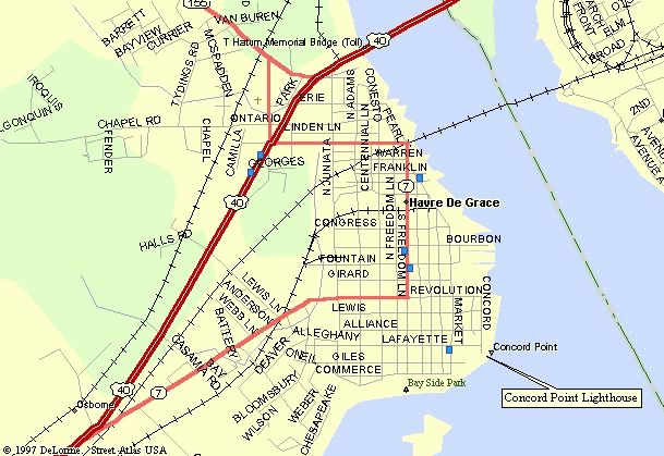
Exit at interchange 89, exit onto State Route 155 (Level Road) and go east about 2.8 miles to U.S. Route 40 (Pulaski Highway). Turn right and go about 0.1 mile to State Route 7 (Otsego Street) and turn left.
Follow Route 7 about 0.56 miles until it turns right onto South Freedom Lane at the railroad tracks underpass. Follow South Freedom Lane about 0.6 miles to Revolution Street and then turn left onto Revolution. Go to the end (about 0.4 miles) and turn right onto Concord Street.
Go 3 blocks and the Concord Point Lighthouse will be on your left. Parking is on the street.
| Large Area Map | Detailed Local Map |
| Some of these maps are large in size and may take a minute or two to load. | |
 2001(c) Chesapeake Chapter, USLHS. All rights reserved.
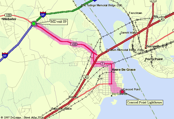