Welcome to the Chesapeake Chapter of the US Lighthouse Society 
As we continue to build our site, each of the lighthouses listed below will become a link showing you a photograph of the lighthouse as well as historical information. Soon there will be maps and directions showing the locations of.....
The Lighthouses Of The Chesapeake Bay
CCUSLHS Logo Our Chesapeake Bay Lighthouse Heritage
CLICK ON THE LINKS TO LEARN MORE
Photos, History, Directions, Maps & More !
View Pictures = PHOTOS
View History = HISTORY
View Directions = DIRECTIONS
View Maps = MAPS
View Timelines = TIMELINE
The symbols on the left appear next to the lighthouse names below to show what kind of information is available on the linked page about that lighthouse. 

Maryland Virginia Lightships Additional Resources
This Month's
F  E  A  T  U  R  E  D        L  I  G  H  T  H  O  U  S  E
Chesapeake Lightship
Photo By: Marie Vincent & Jerry Waters

Chesapeake Lightship, MD
The Chespaeake Lightship is part of the MD Lighthouse Challenge held yearly. The Chapter assists in the continuing restoration efforts ....
........continued on the Heritage Page.
Visit the Heritage Page for more historical information.
See photos and read stories about the fun times we have on our trips and meetings !
Click for more information
 
M  A  R  Y  L  A  N  D      L  I  G  H  T  H  O  U  S  E  S
Are you a member of the 40+3 Club???
Existing Lighthouses "Crossed The Bar"
View PicturesView HistoryView MapsView Timeline Baltimore Harbor Light View PicturesView History Blakistone Island
View PicturesView HistoryView DirectionsView MapsView Timeline Bloody Point Bar View PicturesView History Bodkin Island
View PicturesView HistoryView DirectionsView MapsView Timeline Concord Point Light at Havre de Grace View PicturesView History Brewerton Channel Range
View PicturesView HistoryView DirectionsView MapsView Timeline Cove Point View PicturesView HistoryView Timeline Cedar Point
View PicturesView HistoryView DirectionsView Maps Craighill Channel Range Lights (4) View History Choptank River
View PicturesView HistoryView DirectionsView MapsView Timeline Drum Point (Relocated to Calvert Marine Museum) View History Clay Island
View PicturesView HistoryView MapsView Timeline Fishing Battery View PicturesView History Cobb Point Bar
View PicturesView HistoryView Directions Fort Carroll View History Fog Point
View PicturesView HistoryView DirectionsView MapsView Timeline Fort Washington View PicturesView History Great Shoals
View PicturesView HistoryView DirectionsView MapsView Timeline Hooper Island View PicturesView History Greenbury Point Shoal
View PicturesView HistoryView DirectionsView MapsView Timeline Hooper Strait (Relocated to Chesapeake Bay Maritime Museum) View PicturesView HistoryView Timeline Holland Island Bar
View PicturesView HistoryView DirectionsView Maps Lazaretto Point (Replica)  View PicturesView History Janes Island 
View PicturesView HistoryView DirectionsView MapsView Timeline Piney Point View PicturesView History Love Point
View PicturesView HistoryView DirectionsView MapsView Timeline Point Lookout View PicturesView History Lower Cedar Point
View PicturesView HistoryView DirectionsView MapsView Timeline Point No Point View PicturesView History Maryland Point
View PicturesView HistoryView DirectionsView MapsView Timeline Pooles Island View PicturesView History Mathias Point Shoal
View PicturesView HistoryView DirectionsView Timeline Sandy Point Shoal View PicturesView History Ragged Point
View PicturesView HistoryView DirectionsView MapsView Timeline Sevenfoot Knoll (Relocated to Baltimore's Inner Harbor) View PicturesView History Sharkfin Shoal
View PicturesView HistoryView DirectionsView MapsView Timeline Sharps Island View PicturesView History Somers Cove
View PicturesView HistoryView DirectionsView MapsView Timeline Solomons Lump View PicturesView History Upper Cedar Point
View PicturesView HistoryView DirectionsView MapsView Timeline Thomas Point Shoals . .
View PicturesView HistoryView DirectionsView MapsView Timeline Turkey Point
V  I  R  G  I  N  I  A      L  I  G  H  T  H  O  U  S  E  S
Are you a member of the 40+3 Club???
Existing Lighthouses "Crossed The Bar"
View PicturesView HistoryView DirectionsView MapsView Timeline Assateague View PicturesView History Back River
View PicturesView HistoryView DirectionsView MapsView Timeline Cape Charles View PicturesView History Bells Rock
View PicturesView HistoryView DirectionsView MapsView Timeline Cape Henry (Old) View PicturesView History Bowlers Rock
View PicturesView HistoryView DirectionsView MapsView Timeline Cape Henry (New) View PicturesView History Cherrystone Bar
View PicturesView HistoryView Timeline Chesapeake Light Tower View PicturesView History Craney Island
View PicturesView HistoryView DirectionsView MapsView Timeline Jones Point View PicturesView History Deep Water Shoals
View PicturesView HistoryView DirectionsView MapsView Timeline Newport News Middle Ground View PicturesView History Dutch Gap Canal
View PicturesView HistoryView DirectionsView MapsView Timeline New Point Comfort View PicturesView History Great Wicomico River
View PicturesView HistoryView DirectionsView MapsView Timeline Old Point Comfort View PicturesView History Hog Island
View PicturesView HistoryView DirectionsView MapsView Timeline Smith Point  View PicturesView History Jordan Point
View PicturesView HistoryView DirectionsView MapsView Timeline Thimble Shoal View PicturesView History Killock Shoal
View PicturesView HistoryView DirectionsView MapsView Timeline Wolf Trap View PicturesView History Lambert's Point
. . View PicturesView History Nansemond River
View PicturesView History Old Plantation Flats
. . View PicturesView History Pages Rock
View PicturesView History Point of Shoals
. . View PicturesView History Pungoteague River
View PicturesView History Stingray Point
. . View PicturesView History Tangier Sound
View PicturesView History Tue Marshes
. . View PicturesView History Watts Island
View PicturesView History White Shoal
. . View PicturesView History Windmill Point
View PicturesView History York Spit
D  E  L  A  W  A  R E      L  I  G  H  T  H  O  U  S  E  S
Are you a member of the 40+3 Club???
These three lighthouses are the only ones in Delaware considered to be in the Chesapeake Chapter's "core geographic area"; there are many others located in Delaware and Delaware Bay.
View PicturesView HistoryView DirectionsView Maps Fenwick Island
View PicturesView HistoryView Directions Harbor of Refuge
View PicturesView HistoryView Directions Lewis Breakwater
L  I  G  H  T  H  S  H  I  P  S
Are you a member of the 40+3 Club???
. Bowlers Rock; Bush Bluff . Thirty-Five-Foot Channel
View PicturesView HistoryView DirectionsView MapsView Timeline 
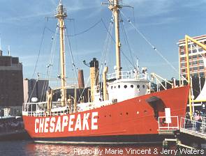
Cape Charles / Chesapeake Upper Cedar Point
. Craney Island . Willoughby Spit
Hooper Strait Windmill Point
. Janes Island . Winter Quarter Shoal
Lower Cedar Point Wolf Trap Shoals
View PicturesView HistoryView Directions Portsmouth . York Spit
. Smith Point
. Tail of the Horseshoe . .
By clicking on the links to the individual lights above you can view pictures and learn about the historical facts surrounding our Chesapeake Heritage. You will also find additional information such as maps and directions to the lights.
Additional Information and resources.....
Learn More Information....Join the 40+3 Club ! Learn More Information....Read books about our lighthouses !
Have you seen all of the area's lighthouses?
Then join the 40+3 Club !
More Details
There are many books about lighthouses.
Click on the link above to see some examples of books about lighthouses in our area.
More Details
  .
Choose another destination....
CCUSLHS Home Page Trips & Meetings
About The Chapter Keeper's Loft - Our Merchandise
Membership Information Photo Contest
Lighthouse Heritage - Maps, Photos & More Lighthouse Links
Our Newsletter - Chesapeake Lights MD Challenge
Volunteer Preservation Program Cheslights Kids
Speakers Program Site Map
2003(c) Chesapeake Chapter, USLHS. All rights reserved.